PROPOSED COAL CREEK FLOOD REDUCTION PLAN
(Draft for review by CCWF Volunteers)
Click on Images to Enlarge
 At our community meeting on July 10, 2000, Steve Allen, PE with TVA discussed
the flooding situation in Coal Creek. He informed us that Coal Creek is
susceptible to intense flooding because of its geographic location (i.e.
mountains located adjacent to flatter terrain) which causes storms to stall over
the watershed. For example, 12 inches of rain fell on Redoak and Cross Mountains
on July 24, 1965. Most of the runoff from the storm drained into the adjacent
Stony Creek watershed. The resulting flood killed a family of five and literally
destroyed the community of Clinchmore.
At our community meeting on July 10, 2000, Steve Allen, PE with TVA discussed
the flooding situation in Coal Creek. He informed us that Coal Creek is
susceptible to intense flooding because of its geographic location (i.e.
mountains located adjacent to flatter terrain) which causes storms to stall over
the watershed. For example, 12 inches of rain fell on Redoak and Cross Mountains
on July 24, 1965. Most of the runoff from the storm drained into the adjacent
Stony Creek watershed. The resulting flood killed a family of five and literally
destroyed the community of Clinchmore.
At a meeting on August 17, 2000, Dave Turner, Environmental Specialist with
TDEC will explain the problems associated with dredging Coal Creek to reduce
flooding. An ecosystem is destroyed and the dredging increases downstream
flooding. A flood reduction plan involving dredging has winners and losers.
Flood reduction plans in the 21st Century need to provide win-win
solutions.
 After conversations with representatives from TVA, TDEC, NRCS, and Anderson
County, the most attractive method to address the flooding problem appears to be
the construction of a dry dam in the unpopulated, upper reaches of Coal Creek.
Dry dams have a successful history as win-win flood management structures that
protect the environment. The Miami Conservancy District in Ohio has been using
these structures since the 1930s. TVA used dry dams to provide flood protection
for Bristol. TVA considered the use of a dry dam to protect Coal Creek from
flooding in the 1970s, but decided on a dredging plan because it was cheaper.
Win-lose plans are often cheaper than win-win plans.
After conversations with representatives from TVA, TDEC, NRCS, and Anderson
County, the most attractive method to address the flooding problem appears to be
the construction of a dry dam in the unpopulated, upper reaches of Coal Creek.
Dry dams have a successful history as win-win flood management structures that
protect the environment. The Miami Conservancy District in Ohio has been using
these structures since the 1930s. TVA used dry dams to provide flood protection
for Bristol. TVA considered the use of a dry dam to protect Coal Creek from
flooding in the 1970s, but decided on a dredging plan because it was cheaper.
Win-lose plans are often cheaper than win-win plans.
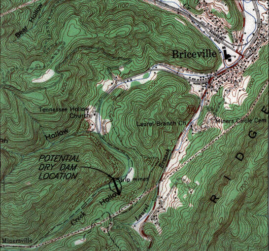
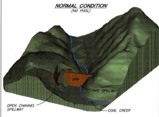
 The proposed flood reduction plan for Coal Creek involves building an 80-foot
high dam in Tennessee Hollow. During normal conditions, no pool is present
upstream of the dry dam. Water would flow through a spillway pipe at the dry
dam. Upstream and downstream of the dam, there would be no change to the stream.
If trout spawning can eventually be achieved, then they could access upstream
areas through the spillway pipe at creek level.
The proposed flood reduction plan for Coal Creek involves building an 80-foot
high dam in Tennessee Hollow. During normal conditions, no pool is present
upstream of the dry dam. Water would flow through a spillway pipe at the dry
dam. Upstream and downstream of the dam, there would be no change to the stream.
If trout spawning can eventually be achieved, then they could access upstream
areas through the spillway pipe at creek level.
 During flood events, water would be temporarily stored upstream of the dry
dam and slowly decanted to reduce flooding. The dry dam would be designed to
store runoff from a 100-year flood below the level of an open channel emergency
spillway. The emergency spillway would then be designed to discharge the
probable maximum flood (PMF) without overtopping the dam. Rainfall for a
100-year, 6-hour storm is 4.9 inches. Rainfall associated with the PMF is 29.5
inches in 6 hours.
During flood events, water would be temporarily stored upstream of the dry
dam and slowly decanted to reduce flooding. The dry dam would be designed to
store runoff from a 100-year flood below the level of an open channel emergency
spillway. The emergency spillway would then be designed to discharge the
probable maximum flood (PMF) without overtopping the dam. Rainfall for a
100-year, 6-hour storm is 4.9 inches. Rainfall associated with the PMF is 29.5
inches in 6 hours.
Based on preliminary calculations, the proposed dry dam would reduce the peak
flow from a 100-year flood by about 40% in Briceville and 17% in Lake City.
Preliminary assessments indicate that TDEC can recommend approval of the dry
dam, provided that extensive stream habitat improvements are made as mitigation
for the section of stream that will be covered by the dam. The proposed plan
will therefore allow for flood reduction and stream habitat improvements, which
should be a win-win scenario for all CCWF volunteers and government agencies.
Implementation of positive flood reduction measures in Coal Creek will be an
involved process that will require TDEC, TVA, and U.S. Army Corps of Engineers
review of plans with other applicable agencies. Adequate funding for
implementation is not guaranteed even if a win-win flood reduction plan is
developed and permitted by the applicable agencies. We will never know if
funding can be obtained until we try. As Rev. Roy Daugherty says:
"sometimes you just need to do the right thing and have faith that others
will do the same."
Before proceeding with this initiative, input is needed from interested
parties. You can email your comments to bthacker2@coalcreekaml.com
or attend the community meeting on August 17, 2000 at 7:00 pm (Briceville
Elementary School) and deliver your comments in person.
[Home]
[SCHOLARSHIPS]
[RESTORING THE GREAT AMERICAN CHESNUTS]
[Master
Plan] [Map] [Photo
Gallery]
[Bank Stabilization Projects]
[Deadwood Removal Days] [Discovery Day 2000] [Scrape,
Paint
& Clean Day 2000]
[Historic Fraterville Mine Disaster Field Trip
2001] [Fraterville Mine Disaster 100th
Anniversary]
[Coal Creek War and Mining Disasters] [Mine
Reclamation Lessons]
[CMD] [Economic Benefits]
[Motor Discovery Trail] [Historic
Cemeteries]
[Partners] [Schools in Watershed]
[Mark the Trail Day]
[Awards]
[Coal Creek Health Days]
[Briceville School History Field
Trips] [Ghost Stories]
[Trout Stuff] [Join
Us] [Eastern
Coal Region Roundtable]
[Articles in the News] [Dream Contest]
Copyright© Coal
Creek Watershed Foundation, Inc. 2000 through 2021
CELEBRATING OUR 21st YEAR!!
 At our community meeting on July 10, 2000, Steve Allen, PE with TVA discussed
the flooding situation in Coal Creek. He informed us that Coal Creek is
susceptible to intense flooding because of its geographic location (i.e.
mountains located adjacent to flatter terrain) which causes storms to stall over
the watershed. For example, 12 inches of rain fell on Redoak and Cross Mountains
on July 24, 1965. Most of the runoff from the storm drained into the adjacent
Stony Creek watershed. The resulting flood killed a family of five and literally
destroyed the community of Clinchmore.
At our community meeting on July 10, 2000, Steve Allen, PE with TVA discussed
the flooding situation in Coal Creek. He informed us that Coal Creek is
susceptible to intense flooding because of its geographic location (i.e.
mountains located adjacent to flatter terrain) which causes storms to stall over
the watershed. For example, 12 inches of rain fell on Redoak and Cross Mountains
on July 24, 1965. Most of the runoff from the storm drained into the adjacent
Stony Creek watershed. The resulting flood killed a family of five and literally
destroyed the community of Clinchmore.